Paralowie night lights from space
Night Light of Paralowie (South Australia) from space (Australia) Src. Average luminocity for 10x10km area is 71.8407% and for 50x50km: 23.7029%.
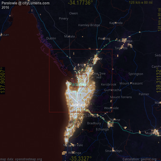
Analysis of Paralowie night lights 2016
Square area 10x10 km:
 17.58%
90-99
21.98%80-89
10.81%70-79
13.19%60-69
6.23%50-59
4.95%40-49
3.85%30-39
9.16%20-29
9.89%10-19
2.38%0-9
0%Square area 50x50 km:
5.45%90-99
5.65%80-89
2.68%70-79
4.29%60-69
3.07%50-59
2.48%40-49
1.76%30-39
1.81%20-29
3.87%10-19
7.68%0-9
61.25%Clear (daylight) street map image can be seen on geolist.org.
Map coordinates:
34° 10' 38.5" South, 137° 54' 18.3" East
34° 45' 25.4" South, 138° 36' 29.5" East
35° 19' 57.7" South, 139° 18' 40.8" East
Some cities around Paralowie sort by population:
• Parafield Gardens
2.8 km =1.7 mi,  175°
175°
• Mawson Lakes
6.5 km =4 mi, 180°
• Salisbury North
1.4 km =0.9 mi,  53°
53°
• Salisbury East
5.6 km =3.5 mi,  131°
131°
• Salisbury
2.5 km =1.6 mi,  114°
114°
• Burton
2.7 km =1.7 mi,  348°
348°
• Salisbury Downs
1.7 km =1.1 mi, 133°
• Salisbury Heights
6.2 km =3.9 mi,  96°
96°
8349003 (p: 16,386)
Sources (retrieved 2019-11-25):
» Earth at Night: Flat Maps 2012, 2016