Parafield Gardens night lights from space
Night Light of Parafield Gardens (South Australia) from space (Australia) Src. Average luminocity for 10x10km area is 77% and for 50x50km: 25.042%.
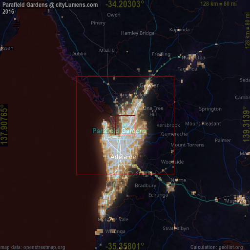
Analysis of Parafield Gardens night lights 2016
Square area 10x10 km:
 20.7%
20.7%90-99
25.27%80-89
10.07%70-79
15.93%60-69
2.93%50-59
6.04%40-49
5.13%30-39
7.51%20-29
6.23%10-19
0.18%0-9
0%Square area 50x50 km:
5.54%90-99
5.94%80-89
2.76%70-79
4.66%60-69
3.55%50-59
2.66%40-49
1.81%30-39
1.98%20-29
4.21%10-19
8.15%0-9
58.76%Clear (daylight) street map image can be seen on geolist.org.
Map coordinates:
34° 12' 10.9" South, 137° 54' 27.5" East
34° 46' 57.1" South, 138° 36' 38.8" East
35° 21' 28.8" South, 139° 18' 50" East
Some cities around Parafield Gardens sort by population:
• Paralowie
2.8 km =1.7 mi,  355°
355°
• Mawson Lakes
3.7 km =2.3 mi,  183°
183°
• Salisbury North
3.8 km =2.4 mi,  13°
13°
• Salisbury East
4.1 km =2.5 mi,  102°
102°
• Salisbury
2.7 km =1.7 mi,  49°
49°
• Pooraka
4.9 km =3 mi,  163°
163°
• Para Hills
5.4 km =3.4 mi,  127°
127°
• Salisbury Downs
1.9 km =1.2 mi,  32°
32°
8349238 (p: 16,872)
Sources (retrieved 2019-11-25):
» Earth at Night: Flat Maps 2012, 2016