Burton night lights from space
Night Light of Burton (South Australia) from space (Australia) Src. Average luminocity for 10x10km area is 62.0659% and for 50x50km: 22.2014%.
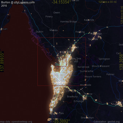
Analysis of Burton night lights 2016
Square area 10x10 km:
 13%
13%90-99
14.84%80-89
8.61%70-79
11.72%60-69
5.68%50-59
8.06%40-49
7.88%30-39
9.89%20-29
11.36%10-19
8.61%0-9
0.37%Square area 50x50 km:
5.19%90-99
5.4%80-89
2.5%70-79
3.76%60-69
2.75%50-59
2.38%40-49
1.73%30-39
1.74%20-29
3.65%10-19
7.26%0-9
63.65%Clear (daylight) street map image can be seen on geolist.org.
Map coordinates:
34° 9' 12.7" South, 137° 53' 57.7" East
34° 44' 0.2" South, 138° 36' 8.9" East
35° 18' 33.1" South, 139° 18' 20.2" East
Some cities around Burton sort by population:
• Parafield Gardens
5.5 km =3.4 mi,  172°
172°
• Paralowie
2.7 km =1.7 mi, 168°
• Salisbury North
2.4 km =1.5 mi,  137°
137°
• Salisbury East
7.9 km =4.9 mi, 143°
• Salisbury
4.7 km =2.9 mi, 142°
• Davoren Park
7.7 km =4.8 mi,  51°
51°
• Salisbury Downs
4.2 km =2.6 mi,  154°
154°
• Salisbury Heights
7.5 km =4.7 mi,  116°
116°
8349396 (p: 6,242)
Sources (retrieved 2019-11-25):
» Earth at Night: Flat Maps 2012, 2016