Parkwood night lights from space
Night Light of Parkwood (Queensland) from space (Australia) Src. Average luminocity for 10x10km area is 78.5322% and for 50x50km: 17.02%.
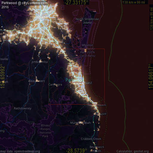
Analysis of Parkwood night lights 2016
Square area 10x10 km:
 20.08%
90-99
25.19%80-89
7.2%70-79
9.85%60-69
17.61%50-59
8.14%40-49
6.44%30-39
4.36%20-29
1.14%10-19
0%0-9
0%Square area 50x50 km:
2.89%90-99
3.03%80-89
1.46%70-79
1.3%60-69
5.05%50-59
1.84%40-49
1.89%30-39
2.11%20-29
4.4%10-19
10.37%0-9
65.66%Clear (daylight) street map image can be seen on geolist.org.
Map coordinates:
27° 19' 54.3" South, 152° 39' 35.7" East
27° 57' 16.6" South, 153° 21' 46.9" East
28° 34' 26" South, 154° 3' 58.2" East
Some cities around Parkwood sort by population:
• Southport
3.7 km =2.3 mi,  112°
112°
• Labrador
3.6 km =2.2 mi,  71°
71°
• Nerang
4.7 km =2.9 mi,  214°
214°
• Ashmore
4 km =2.5 mi,  160°
160°
• Coombabah
4.9 km =3 mi,  9°
9°
• Arundel
1.9 km =1.2 mi,  359°
359°
• Biggera Waters
4.4 km =2.7 mi,  55°
55°
• Molendinar
2.2 km =1.4 mi,  186°
186°
8348307 (p: 8,656)
Sources (retrieved 2019-11-25):
» Earth at Night: Flat Maps 2012, 2016