Ringwood East night lights from space
Night Light of Ringwood East (Victoria) from space (Australia) Src. Average luminocity for 10x10km area is 69.3163% and for 50x50km: 39.1342%.
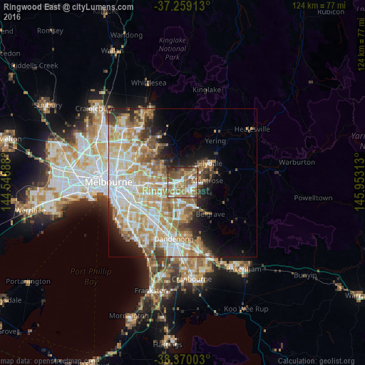
Analysis of Ringwood East night lights 2016
Square area 10x10 km:
 11.56%
90-99
11.9%80-89
5.27%70-79
11.39%60-69
25.34%50-59
19.05%40-49
12.24%30-39
1.53%20-29
1.7%10-19
0%0-9
0%Square area 50x50 km:
8.49%90-99
8.99%80-89
4.72%70-79
7.85%60-69
6.98%50-59
5.1%40-49
3.27%30-39
2.7%20-29
4.49%10-19
6.5%0-9
40.91%Clear (daylight) street map image can be seen on geolist.org.
Map coordinates:
37° 15' 32.9" South, 144° 32' 48.8" East
37° 49' 0" South, 145° 15' 0" East
38° 22' 12.1" South, 145° 57' 11.3" East
Some cities around Ringwood East sort by population:
• Croydon
3.5 km =2.2 mi,  57°
57°
• Mitcham
4.4 km =2.7 mi,  270°
270°
• Wantirna
4.7 km =2.9 mi,  218°
218°
• Bayswater
4 km =2.5 mi,  158°
158°
• Kilsyth
6.1 km =3.8 mi,  72°
72°
• Vermont
5.4 km =3.4 mi,  246°
246°
• Heathmont
1.9 km =1.2 mi,  180°
180°
• Bayswater North
4.4 km =2.7 mi,  103°
103°
2151575 (p: 10,347)
Sources (retrieved 2019-11-25):
» Earth at Night: Flat Maps 2012, 2016