Bayswater North night lights from space
Night Light of Bayswater North (Victoria) from space (Australia) Src. Average luminocity for 10x10km area is 56.1701% and for 50x50km: 33.7568%.
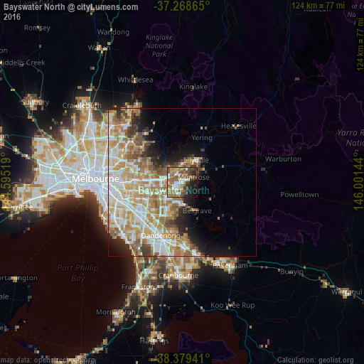
Analysis of Bayswater North night lights 2016
Square area 10x10 km:
 7.48%
7.48%90-99
7.99%80-89
3.4%70-79
10.2%60-69
17.86%50-59
13.78%40-49
11.39%30-39
6.63%20-29
10.2%10-19
9.35%0-9
1.7%Square area 50x50 km:
6.2%90-99
7.63%80-89
3.95%70-79
7.1%60-69
6.85%50-59
4.89%40-49
3.12%30-39
2.46%20-29
3.81%10-19
6.27%0-9
47.71%Clear (daylight) street map image can be seen on geolist.org.
Map coordinates:
37° 16' 7.1" South, 144° 35' 42.7" East
37° 49' 34" South, 145° 17' 53.9" East
38° 22' 45.9" South, 146° 0' 5.2" East
Some cities around Bayswater North sort by population:
• Croydon
3.2 km =2 mi,  335°
335°
• Boronia
4.7 km =2.9 mi,  196°
196°
• Mooroolbark
5.1 km =3.2 mi,  18°
18°
• Ringwood
5.8 km =3.6 mi,  280°
280°
• Kilsyth
3.3 km =2.1 mi,  29°
29°
• Ringwood East
4.4 km =2.7 mi, 283°
• Heathmont
4.3 km =2.7 mi,  259°
259°
• Montrose
4.7 km =2.9 mi,  76°
76°
9972470 (p: 8,654)
Sources (retrieved 2019-11-25):
» Earth at Night: Flat Maps 2012, 2016