Raymond Terrace night lights from space
Night Light of Raymond Terrace (New South Wales) from space (Australia) Src. Average luminocity for 10x10km area is 13.6521% and for 50x50km: 12.4861%.
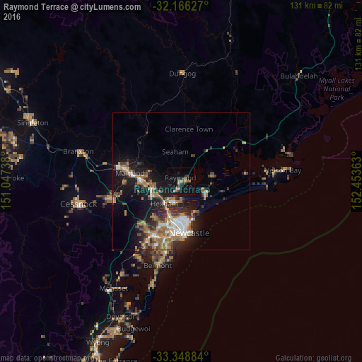
Analysis of Raymond Terrace night lights 2016
Square area 10x10 km:
 0.7%
0.7%90-99
0.7%80-89
0.35%70-79
2.62%60-69
2.97%50-59
1.75%40-49
1.92%30-39
2.8%20-29
0.87%10-19
17.66%0-9
67.66%Square area 50x50 km:
1.48%90-99
1.71%80-89
0.39%70-79
2.05%60-69
3.59%50-59
1.54%40-49
1.5%30-39
2.56%20-29
3.07%10-19
8.85%0-9
73.26%Clear (daylight) street map image can be seen on geolist.org.
Map coordinates:
32° 9' 58.6" South, 151° 2' 50.6" East
32° 45' 34.3" South, 151° 45' 1.8" East
33° 20' 55.8" South, 152° 27' 13.1" East
Some cities around Raymond Terrace sort by population:
• Maitland
18.3 km =11.4 mi,  279°
279°
• Wallsend
17.7 km =11 mi,  207°
207°
• East Maitland
15.7 km =9.8 mi,  273°
273°
• Medowie
11.1 km =6.9 mi,  79°
79°
• Mayfield
15.4 km =9.6 mi,  184°
184°
• Thornton
11.3 km =7 mi,  256°
256°
• Maryland
15.7 km =9.8 mi, 212°
• Fletcher
16.2 km =10.1 mi,  219°
219°
2152022 (p: 12,620)
Sources (retrieved 2019-11-25):
» Earth at Night: Flat Maps 2012, 2016