Thornton night lights from space
Night Light of Thornton (New South Wales) from space (Australia) Src. Average luminocity for 10x10km area is 35.0385% and for 50x50km: 13.9761%.
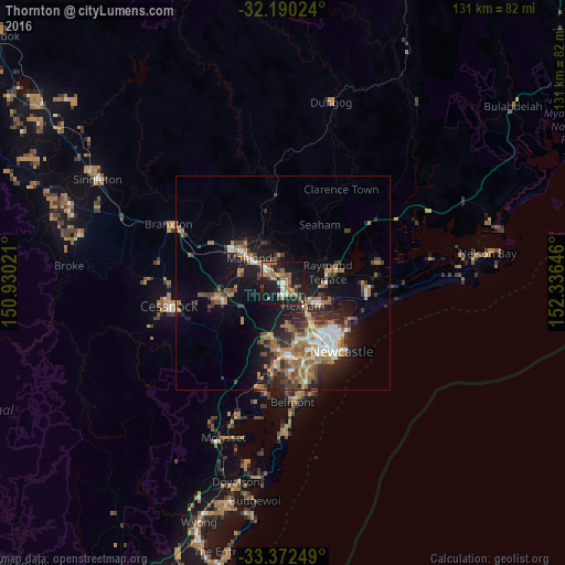
Analysis of Thornton night lights 2016
Square area 10x10 km:
 2.1%
2.1%90-99
3.5%80-89
1.4%70-79
5.59%60-69
17.31%50-59
3.85%40-49
1.92%30-39
6.99%20-29
5.77%10-19
40.03%0-9
11.54%Square area 50x50 km:
1.49%90-99
1.74%80-89
0.44%70-79
2.24%60-69
4.08%50-59
1.85%40-49
1.73%30-39
3.02%20-29
3.58%10-19
9.58%0-9
70.23%Clear (daylight) street map image can be seen on geolist.org.
Map coordinates:
32° 11' 24.9" South, 150° 55' 48.8" East
32° 46' 60" South, 151° 37' 60" East
33° 22' 21" South, 152° 20' 11.3" East
Some cities around Thornton sort by population:
• Maitland
9 km =5.6 mi,  308°
308°
• Raymond Terrace
11.3 km =7 mi,  76°
76°
• Wallsend
13.4 km =8.3 mi,  167°
167°
• Rutherford
11.9 km =7.4 mi, 308°
• East Maitland
6 km =3.7 mi, 308°
• Maryland
10.9 km =6.8 mi, 166°
• Aberglasslyn
13.2 km =8.2 mi, 314°
• Fletcher
9.9 km =6.2 mi,  176°
176°
2146777 (p: 7,879)
Sources (retrieved 2019-11-25):
» Earth at Night: Flat Maps 2012, 2016