Fletcher night lights from space
Night Light of Fletcher (New South Wales) from space (Australia) Src. Average luminocity for 10x10km area is 32.9066% and for 50x50km: 15.391%.
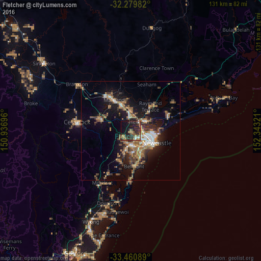
Analysis of Fletcher night lights 2016
Square area 10x10 km:
 2.38%
2.38%90-99
2.38%80-89
0.92%70-79
4.4%60-69
10.81%50-59
3.85%40-49
5.86%30-39
8.97%20-29
18.5%10-19
30.22%0-9
11.72%Square area 50x50 km:
1.5%90-99
1.76%80-89
0.53%70-79
2.41%60-69
4.41%50-59
2.12%40-49
2.12%30-39
3.48%20-29
3.8%10-19
10.89%0-9
66.95%Clear (daylight) street map image can be seen on geolist.org.
Map coordinates:
32° 16' 47.4" South, 150° 56' 13.1" East
32° 52' 20.4" South, 151° 38' 24.3" East
33° 27' 39.2" South, 152° 20' 35.6" East
Some cities around Fletcher sort by population:
• Wallsend
3.9 km =2.4 mi,  144°
144°
• New Lambton
8.9 km =5.5 mi,  134°
134°
• Mayfield
9.4 km =5.8 mi,  107°
107°
• Thornton
9.9 km =6.2 mi,  356°
356°
• Cameron Park
5 km =3.1 mi,  220°
220°
• Maryland
2.1 km =1.3 mi, 110°
• Edgeworth
6.3 km =3.9 mi,  200°
200°
• Elermore Vale
6 km =3.7 mi,  145°
145°
8348859 (p: 5,050)
Sources (retrieved 2019-11-25):
» Earth at Night: Flat Maps 2012, 2016