Ormond night lights from space
Night Light of Ormond (Victoria) from space (Australia) Src. Average luminocity for 10x10km area is 88.1201% and for 50x50km: 54.1863%.
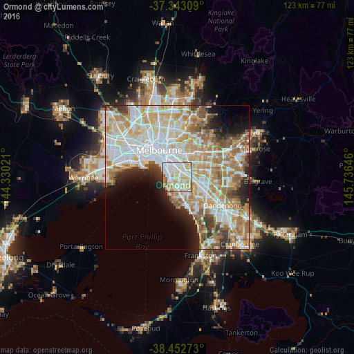
Analysis of Ormond night lights 2016
Square area 10x10 km:
 32.31%
90-99
28.9%80-89
13.64%70-79
15.42%60-69
3.41%50-59
2.76%40-49
0.16%30-39
1.46%20-29
1.95%10-19
0%0-9
0%Square area 50x50 km:
15.05%90-99
13.66%80-89
7.09%70-79
9.4%60-69
7.87%50-59
5.54%40-49
3.68%30-39
3.13%20-29
4.23%10-19
5.29%0-9
25.06%Clear (daylight) street map image can be seen on geolist.org.
Map coordinates:
37° 20' 35.1" South, 144° 19' 48.8" East
37° 54' 0" South, 145° 1' 60" East
38° 27' 9.8" South, 145° 44' 11.3" East
Some cities around Ormond sort by population:
• Bentleigh East
2.8 km =1.7 mi,  141°
141°
• Brighton
2.8 km =1.7 mi,  256°
256°
• Carnegie
2.1 km =1.3 mi,  69°
69°
• Bentleigh
2 km =1.2 mi,  174°
174°
• Brighton East
1.4 km =0.9 mi, 259°
• Caulfield South
0.8 km =0.5 mi,  307°
307°
• Caulfield
2.2 km =1.4 mi,  334°
334°
• McKinnon
2.4 km =1.5 mi, 141°
2154172 (p: 7,711)
Sources (retrieved 2019-11-25):
» Earth at Night: Flat Maps 2012, 2016