Caulfield night lights from space
Night Light of Caulfield (Victoria) from space (Australia) Src. Average luminocity for 10x10km area is 88.888% and for 50x50km: 55.0381%.
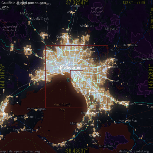
Analysis of Caulfield night lights 2016
Square area 10x10 km:
 38.31%
90-99
27.76%80-89
12.99%70-79
10.55%60-69
2.27%50-59
2.92%40-49
0.65%30-39
2.44%20-29
2.11%10-19
0%0-9
0%Square area 50x50 km:
15.43%90-99
13.93%80-89
7.12%70-79
9.41%60-69
8.22%50-59
5.36%40-49
3.61%30-39
3.3%20-29
4.39%10-19
5.19%0-9
24.03%Clear (daylight) street map image can be seen on geolist.org.
Map coordinates:
37° 19' 31.7" South, 144° 19' 11.1" East
37° 52' 57" South, 145° 1' 22.4" East
38° 26' 7.3" South, 145° 43' 33.6" East
Some cities around Caulfield sort by population:
• Malvern East
2 km =1.2 mi,  61°
61°
• Brighton East
2.3 km =1.4 mi,  192°
192°
• St Kilda East
2.7 km =1.7 mi,  312°
312°
• Elsternwick
1.8 km =1.1 mi,  256°
256°
• Malvern
2.3 km =1.4 mi,  11°
11°
• Armadale
3 km =1.9 mi,  356°
356°
• Ormond
2.2 km =1.4 mi,  154°
154°
• Balaclava
2.7 km =1.7 mi, 311°
2171948 (p: 5,731)
Sources (retrieved 2019-11-25):
» Earth at Night: Flat Maps 2012, 2016