Eastwood night lights from space
Night Light of Eastwood (New South Wales) from space (Australia) Src. Average luminocity for 10x10km area is 82.7605% and for 50x50km: 53.2612%.
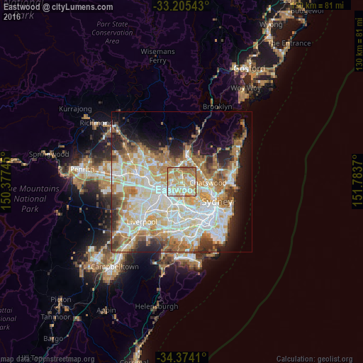
Analysis of Eastwood night lights 2016
Square area 10x10 km:
 15.03%
90-99
23.43%80-89
15.21%70-79
26.57%60-69
15.91%50-59
3.85%40-49
0%30-39
0%20-29
0%10-19
0%0-9
0%Square area 50x50 km:
12.51%90-99
14.01%80-89
7.3%70-79
8.67%60-69
9.46%50-59
4.82%40-49
3.05%30-39
4.39%20-29
5.61%10-19
7.66%0-9
22.53%Clear (daylight) street map image can be seen on geolist.org.
Map coordinates:
33° 12' 19.5" South, 150° 22' 38.8" East
33° 47' 30.3" South, 151° 4' 50.1" East
34° 22' 26.8" South, 151° 47' 1.3" East
Some cities around Eastwood sort by population:
• Ryde
3.8 km =2.4 mi,  141°
141°
• Carlingford
3.1 km =1.9 mi,  289°
289°
• Epping
2.1 km =1.3 mi,  3°
3°
• West Ryde
1.6 km =1 mi,  202°
202°
• Marsfield
2.8 km =1.7 mi,  56°
56°
• Rhodes
3.9 km =2.4 mi,  169°
169°
• Ermington
3.5 km =2.2 mi,  223°
223°
• Dundas Valley
2.6 km =1.6 mi,  278°
278°
2167840 (p: 17,792)
Sources (retrieved 2019-11-25):
» Earth at Night: Flat Maps 2012, 2016