North Rocks night lights from space
Night Light of North Rocks (New South Wales) from space (Australia) Src. Average luminocity for 10x10km area is 83.3993% and for 50x50km: 54.027%.
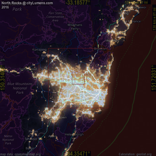
Analysis of North Rocks night lights 2016
Square area 10x10 km:
 16.48%
90-99
21.98%80-89
14.65%70-79
31.14%60-69
15.75%50-59
0%40-49
0%30-39
0%20-29
0%10-19
0%0-9
0%Square area 50x50 km:
12.93%90-99
14.22%80-89
7.17%70-79
8.81%60-69
9.24%50-59
4.61%40-49
3.42%30-39
4.96%20-29
6.34%10-19
7.36%0-9
20.93%Clear (daylight) street map image can be seen on geolist.org.
Map coordinates:
33° 11' 8.8" South, 150° 18' 50.6" East
33° 46' 20" South, 151° 1' 1.8" East
34° 21' 17" South, 151° 43' 13.1" East
Some cities around North Rocks sort by population:
• Baulkham Hills
2.7 km =1.7 mi,  303°
303°
• Carlingford
3.2 km =2 mi,  111°
111°
• Westmead
4.4 km =2.7 mi,  217°
217°
• West Pennant Hills
4.1 km =2.5 mi,  43°
43°
• Winston Hills
3.4 km =2.1 mi,  262°
262°
• Oatlands
2.8 km =1.7 mi,  160°
160°
• Telopea
3 km =1.9 mi,  139°
139°
• Dundas Valley
3.7 km =2.3 mi,  118°
118°
8347895 (p: 7,899)
Sources (retrieved 2019-11-25):
» Earth at Night: Flat Maps 2012, 2016