Oatlands night lights from space
Night Light of Oatlands (New South Wales) from space (Australia) Src. Average luminocity for 10x10km area is 86.7587% and for 50x50km: 56.2709%.
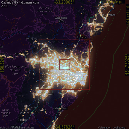
Analysis of Oatlands night lights 2016
Square area 10x10 km:
 23.43%
90-99
26.22%80-89
13.46%70-79
27.97%60-69
8.92%50-59
0%40-49
0%30-39
0%20-29
0%10-19
0%0-9
0%Square area 50x50 km:
13.08%90-99
14.49%80-89
7.49%70-79
9.15%60-69
10.06%50-59
5.1%40-49
3.75%30-39
5.25%20-29
7.22%10-19
7.91%0-9
16.5%Clear (daylight) street map image can be seen on geolist.org.
Map coordinates:
33° 12' 34.7" South, 150° 19' 26.4" East
33° 47' 45.4" South, 151° 1' 37.6" East
34° 22' 41.7" South, 151° 43' 48.9" East
Some cities around Oatlands sort by population:
• Carlingford
2.5 km =1.6 mi,  53°
53°
• North Parramatta
2.4 km =1.5 mi,  276°
276°
• Northmead
3 km =1.9 mi,  297°
297°
• Ermington
3.3 km =2.1 mi,  129°
129°
• North Rocks
2.8 km =1.7 mi,  340°
340°
• Rydalmere
2.3 km =1.4 mi,  155°
155°
• Telopea
1.1 km =0.7 mi,  71°
71°
• Dundas Valley
2.5 km =1.6 mi, 70°
8349217 (p: 5,598)
Sources (retrieved 2019-11-25):
» Earth at Night: Flat Maps 2012, 2016