Dundas Valley night lights from space
Night Light of Dundas Valley (New South Wales) from space (Australia) Src. Average luminocity for 10x10km area is 82.7413% and for 50x50km: 54.9577%.
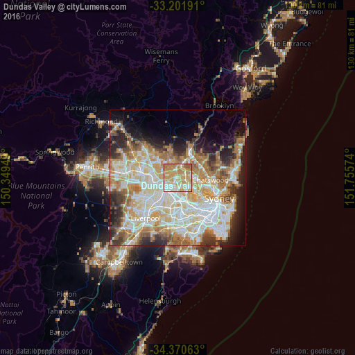
Analysis of Dundas Valley night lights 2016
Square area 10x10 km:
 15.21%
90-99
23.6%80-89
13.99%70-79
27.8%60-69
16.26%50-59
3.15%40-49
0%30-39
0%20-29
0%10-19
0%0-9
0%Square area 50x50 km:
12.81%90-99
14.35%80-89
7.4%70-79
9.01%60-69
9.74%50-59
4.81%40-49
3.45%30-39
5.01%20-29
6.65%10-19
7.66%0-9
19.1%Clear (daylight) street map image can be seen on geolist.org.
Map coordinates:
33° 12' 6.9" South, 150° 20' 58.2" East
33° 47' 17.7" South, 151° 3' 9.4" East
34° 22' 14.3" South, 151° 45' 20.7" East
Some cities around Dundas Valley sort by population:
• Carlingford
0.7 km =0.4 mi,  330°
330°
• Epping
3.2 km =2 mi,  57°
57°
• Eastwood
2.6 km =1.6 mi,  98°
98°
• West Ryde
2.7 km =1.7 mi,  134°
134°
• Ermington
3 km =1.9 mi,  176°
176°
• Rydalmere
3.2 km =2 mi,  205°
205°
• Oatlands
2.5 km =1.6 mi,  250°
250°
• Telopea
1.4 km =0.9 mi, 248°
9972660 (p: 5,374)
Sources (retrieved 2019-11-25):
» Earth at Night: Flat Maps 2012, 2016