Winston Hills night lights from space
Night Light of Winston Hills (New South Wales) from space (Australia) Src. Average luminocity for 10x10km area is 87.4908% and for 50x50km: 53.3075%.
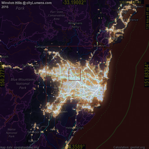
Analysis of Winston Hills night lights 2016
Square area 10x10 km:
 24.18%
90-99
28.02%80-89
14.65%70-79
25.27%60-69
7.88%50-59
0%40-49
0%30-39
0%20-29
0%10-19
0%0-9
0%Square area 50x50 km:
12.71%90-99
13.85%80-89
7.12%70-79
8.81%60-69
9.11%50-59
4.54%40-49
3.35%30-39
4.86%20-29
6.26%10-19
7.59%0-9
21.81%Clear (daylight) street map image can be seen on geolist.org.
Map coordinates:
33° 11' 24.1" South, 150° 16' 38.6" East
33° 46' 35.2" South, 150° 58' 49.8" East
34° 21' 32" South, 151° 41' 1.1" East
Some cities around Winston Hills sort by population:
• Baulkham Hills
2.3 km =1.4 mi,  30°
30°
• Westmead
3.1 km =1.9 mi,  167°
167°
• Toongabbie
2.9 km =1.8 mi,  254°
254°
• North Parramatta
2.7 km =1.7 mi,  134°
134°
• Wentworthville
3.5 km =2.2 mi,  199°
199°
• Northmead
1.9 km =1.2 mi,  116°
116°
• North Rocks
3.4 km =2.1 mi,  82°
82°
• Pendle Hill
3.8 km =2.4 mi,  217°
217°
8347959 (p: 11,572)
Sources (retrieved 2019-11-25):
» Earth at Night: Flat Maps 2012, 2016