West Pennant Hills night lights from space
Night Light of West Pennant Hills (New South Wales) from space (Australia) Src. Average luminocity for 10x10km area is 71.707% and for 50x50km: 50.8255%.
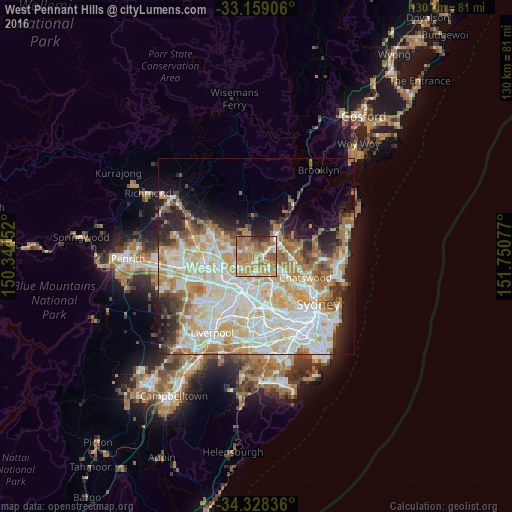
Analysis of West Pennant Hills night lights 2016
Square area 10x10 km:
 5.31%
5.31%90-99
12.64%80-89
5.68%70-79
30.04%60-69
29.12%50-59
9.89%40-49
3.85%30-39
2.93%20-29
0.55%10-19
0%0-9
0%Square area 50x50 km:
12.34%90-99
13.79%80-89
7.13%70-79
8.48%60-69
8.58%50-59
3.64%40-49
2.75%30-39
3.71%20-29
5.59%10-19
7.01%0-9
26.98%Clear (daylight) street map image can be seen on geolist.org.
Map coordinates:
33° 9' 32.6" South, 150° 20' 40.3" East
33° 44' 44.5" South, 151° 2' 51.5" East
34° 19' 42.1" South, 151° 45' 2.8" East
Some cities around West Pennant Hills sort by population:
• Castle Hill
4.6 km =2.9 mi,  287°
287°
• Carlingford
4.1 km =2.5 mi,  178°
178°
• Epping
4.4 km =2.7 mi,  133°
133°
• Cherrybrook
2.6 km =1.6 mi,  356°
356°
• Beecroft
1.6 km =1 mi,  105°
105°
• Thornleigh
3.3 km =2.1 mi,  62°
62°
• North Rocks
4.1 km =2.5 mi,  223°
223°
• Pennant Hills
2.4 km =1.5 mi,  68°
68°
9972964 (p: 16,162)
Sources (retrieved 2019-11-25):
» Earth at Night: Flat Maps 2012, 2016