Woollahra night lights from space
Night Light of Woollahra (New South Wales) from space (Australia) Src. Average luminocity for 10x10km area is 81.9161% and for 50x50km: 37.5911%.
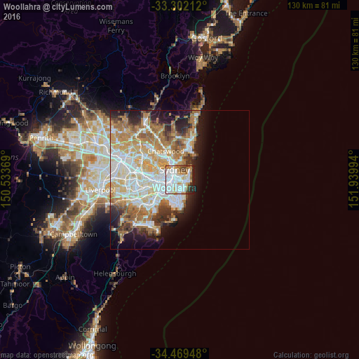
Analysis of Woollahra night lights 2016
Square area 10x10 km:
 34.97%
90-99
24.83%80-89
4.37%70-79
10.31%60-69
6.29%50-59
4.37%40-49
5.07%30-39
2.8%20-29
6.82%10-19
0.17%0-9
0%Square area 50x50 km:
8.82%90-99
9.33%80-89
4.52%70-79
6.12%60-69
7.41%50-59
3.51%40-49
2.39%30-39
3.2%20-29
4.49%10-19
7.34%0-9
42.87%Clear (daylight) street map image can be seen on geolist.org.
Map coordinates:
33° 18' 7.6" South, 150° 32' 1.3" East
33° 53' 16.1" South, 151° 14' 12.5" East
34° 28' 10.1" South, 151° 56' 23.8" East
Some cities around Woollahra sort by population:
• Surry Hills
2.3 km =1.4 mi,  281°
281°
• Paddington
0.6 km =0.4 mi,  309°
309°
• Potts Point
2.5 km =1.6 mi,  336°
336°
• Darlinghurst
1.9 km =1.2 mi,  299°
299°
• Bellevue Hill
1.6 km =1 mi,  53°
53°
• Bondi
2.7 km =1.7 mi,  105°
105°
• Bondi Junction
1.1 km =0.7 mi,  119°
119°
• Elizabeth Bay
2 km =1.2 mi,  333°
333°
6621357 (p: 7,278)
Sources (retrieved 2019-11-25):
» Earth at Night: Flat Maps 2012, 2016