Bronte night lights from space
Night Light of Bronte (New South Wales) from space (Australia) Src. Average luminocity for 10x10km area is 60.1801% and for 50x50km: 33.9366%.
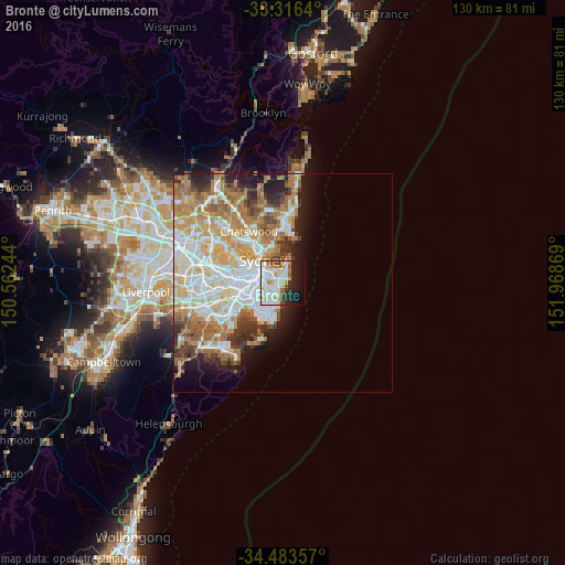
Analysis of Bronte night lights 2016
Square area 10x10 km:
 18.18%
90-99
20.98%80-89
4.9%70-79
7.69%60-69
3.5%50-59
2.1%40-49
4.72%30-39
1.57%20-29
12.24%10-19
16.43%0-9
7.69%Square area 50x50 km:
8.03%90-99
8.43%80-89
4.12%70-79
5.37%60-69
6.88%50-59
3.27%40-49
2.13%30-39
2.94%20-29
3.91%10-19
5.79%0-9
49.13%Clear (daylight) street map image can be seen on geolist.org.
Map coordinates:
33° 18' 59" South, 150° 33' 44.8" East
33° 54' 7.1" South, 151° 15' 56" East
34° 29' 0.9" South, 151° 58' 7.3" East
Some cities around Bronte sort by population:
• Randwick
2.1 km =1.3 mi,  228°
228°
• Coogee
2.3 km =1.4 mi,  204°
204°
• Bondi Beach
1.7 km =1.1 mi,  43°
43°
• Bellevue Hill
2.9 km =1.8 mi,  332°
332°
• Bondi
0.9 km =0.6 mi,  353°
353°
• Bondi Junction
2 km =1.2 mi,  301°
301°
• North Bondi
2.1 km =1.3 mi, 41°
• Woollahra
3.1 km =1.9 mi, 300°
2208288 (p: 6,553)
Sources (retrieved 2019-11-25):
» Earth at Night: Flat Maps 2012, 2016