Mordialloc night lights from space
Night Light of Mordialloc (Victoria) from space (Australia) Src. Average luminocity for 10x10km area is 56.3166% and for 50x50km: 42.2459%.
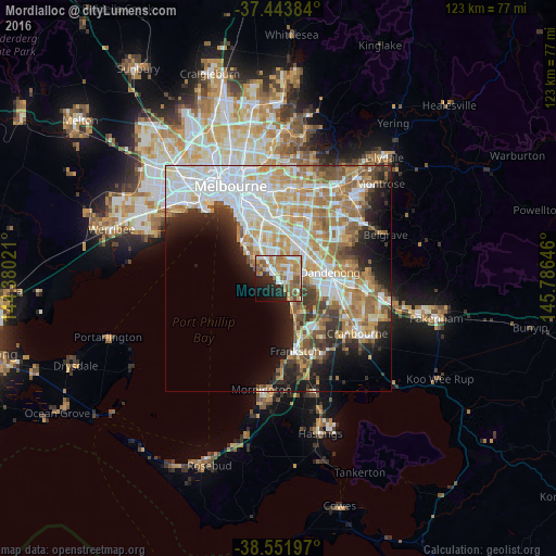
Analysis of Mordialloc night lights 2016
Square area 10x10 km:
 7.31%
7.31%90-99
12.99%80-89
4.22%70-79
14.12%60-69
13.31%50-59
10.88%40-49
4.38%30-39
2.27%20-29
12.66%10-19
11.69%0-9
6.17%Square area 50x50 km:
11.06%90-99
9.55%80-89
4.23%70-79
7.01%60-69
6.75%50-59
5.41%40-49
3.49%30-39
3.79%20-29
5.64%10-19
8.26%0-9
34.81%Clear (daylight) street map image can be seen on geolist.org.
Map coordinates:
37° 26' 37.8" South, 144° 22' 48.8" East
38° 0' 0" South, 145° 4' 60" East
38° 33' 7.1" South, 145° 47' 11.3" East
Some cities around Mordialloc sort by population:
• Cheltenham
4.6 km =2.9 mi,  317°
317°
• Beaumaris
4.7 km =2.9 mi,  290°
290°
• Mentone
2.4 km =1.5 mi, 321°
• Parkdale
0.9 km =0.6 mi,  348°
348°
• Dingley Village
4.9 km =3 mi,  66°
66°
• Aspendale
3.7 km =2.3 mi,  152°
152°
• Aspendale Gardens
4 km =2.5 mi,  129°
129°
• Edithvale
4.7 km =2.9 mi, 150°
2156933 (p: 8,027)
Sources (retrieved 2019-11-25):
» Earth at Night: Flat Maps 2012, 2016