Mentone night lights from space
Night Light of Mentone (Victoria) from space (Australia) Src. Average luminocity for 10x10km area is 64.3636% and for 50x50km: 45.4448%.
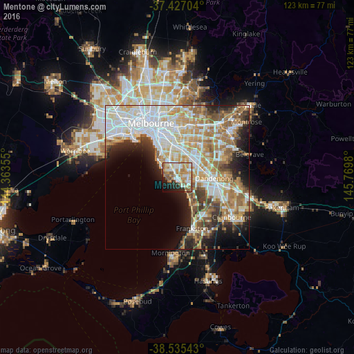
Analysis of Mentone night lights 2016
Square area 10x10 km:
 12.18%
90-99
16.56%80-89
6.33%70-79
14.61%60-69
13.15%50-59
9.9%40-49
3.08%30-39
1.62%20-29
10.23%10-19
9.74%0-9
2.6%Square area 50x50 km:
12.21%90-99
10.63%80-89
4.93%70-79
7.36%60-69
7.03%50-59
5.66%40-49
3.56%30-39
3.73%20-29
5.76%10-19
7.21%0-9
31.92%Clear (daylight) street map image can be seen on geolist.org.
Map coordinates:
37° 25' 37.3" South, 144° 21' 48.8" East
37° 58' 60" South, 145° 4' 0" East
38° 32' 7.5" South, 145° 46' 11.3" East
Some cities around Mentone sort by population:
• Cheltenham
2.2 km =1.4 mi,  313°
313°
• Beaumaris
2.9 km =1.8 mi,  265°
265°
• Parkdale
1.6 km =1 mi,  126°
126°
• Highett
4 km =2.5 mi,  338°
338°
• Mordialloc
2.4 km =1.5 mi,  141°
141°
• Clarinda
5.7 km =3.5 mi,  33°
33°
• Black Rock
4.5 km =2.8 mi,  283°
283°
• Moorabbin
4.7 km =2.9 mi,  350°
350°
2158109 (p: 12,620)
Sources (retrieved 2019-11-25):
» Earth at Night: Flat Maps 2012, 2016