Edithvale night lights from space
Night Light of Edithvale (Victoria) from space (Australia) Src. Average luminocity for 10x10km area is 43.3506% and for 50x50km: 36.0935%.
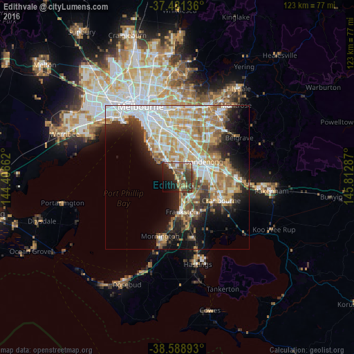
Analysis of Edithvale night lights 2016
Square area 10x10 km:
 2.76%
2.76%90-99
5.84%80-89
5.68%70-79
5.03%60-69
8.6%50-59
12.66%40-49
8.77%30-39
13.47%20-29
12.34%10-19
15.1%0-9
9.74%Square area 50x50 km:
8.45%90-99
7.74%80-89
3.54%70-79
6.31%60-69
6.05%50-59
4.75%40-49
3.21%30-39
3.58%20-29
5.63%10-19
9.89%0-9
40.85%Clear (daylight) street map image can be seen on geolist.org.
Map coordinates:
37° 28' 52.9" South, 144° 24' 23.8" East
38° 2' 14.1" South, 145° 6' 35.1" East
38° 35' 20.1" South, 145° 48' 46.3" East
Some cities around Edithvale sort by population:
• Parkdale
5.6 km =3.5 mi,  333°
333°
• Mordialloc
4.7 km =2.9 mi, 330°
• Chelsea
1.5 km =0.9 mi,  156°
156°
• Patterson Lakes
4.6 km =2.9 mi,  140°
140°
• Aspendale
1.1 km =0.7 mi, 325°
• Aspendale Gardens
1.8 km =1.1 mi,  24°
24°
• Bonbeach
3.3 km =2.1 mi, 159°
• Chelsea Heights
2.1 km =1.3 mi,  78°
78°
2167751 (p: 5,683)
Sources (retrieved 2019-11-25):
» Earth at Night: Flat Maps 2012, 2016