Manly Vale night lights from space
Night Light of Manly Vale (New South Wales) from space (Australia) Src. Average luminocity for 10x10km area is 61.0256% and for 50x50km: 32.6182%.
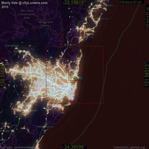
Analysis of Manly Vale night lights 2016
Square area 10x10 km:
 8.97%
8.97%90-99
10.99%80-89
5.49%70-79
5.68%60-69
26.74%50-59
10.44%40-49
9.16%30-39
6.41%20-29
9.71%10-19
6.41%0-9
0%Square area 50x50 km:
7.73%90-99
8.24%80-89
3.97%70-79
5.13%60-69
6.58%50-59
2.96%40-49
1.78%30-39
2.77%20-29
3.51%10-19
5.82%0-9
51.52%Clear (daylight) street map image can be seen on geolist.org.
Map coordinates:
33° 11' 53.5" South, 150° 33' 32" East
33° 47' 4.5" South, 151° 15' 43.2" East
34° 22' 1.1" South, 151° 57' 54.5" East
Some cities around Manly Vale sort by population:
• Dee Why
4.5 km =2.8 mi,  33°
33°
• Freshwater
2.3 km =1.4 mi,  73°
73°
• Balgowlah
1.2 km =0.7 mi,  201°
201°
• Beacon Hill
3.5 km =2.2 mi,  354°
354°
• Seaforth
2.8 km =1.7 mi,  227°
227°
• Allambie Heights
2.3 km =1.4 mi,  330°
330°
• Narraweena
3.5 km =2.2 mi,  22°
22°
• Fairlight
1.6 km =1 mi,  139°
139°
11704259 (p: 6,057)
Sources (retrieved 2019-11-25):
» Earth at Night: Flat Maps 2012, 2016