Dee Why night lights from space
Night Light of Dee Why (New South Wales) from space (Australia) Src. Average luminocity for 10x10km area is 43.7454% and for 50x50km: 27.6079%.
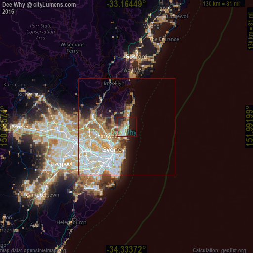

Analysis of Dee Why night lights 2016
Square area 10x10 km:
 5.68%
5.68%90-99
7.51%80-89
4.21%70-79
4.76%60-69
13.37%50-59
4.4%40-49
5.49%30-39
8.06%20-29
16.48%10-19
19.41%0-9
10.62%Square area 50x50 km:
6.85%90-99
7.18%80-89
3.38%70-79
4.18%60-69
5.37%50-59
2.1%40-49
1.33%30-39
2%20-29
2.91%10-19
5.27%0-9
59.42%Clear (daylight) street map image can be seen on geolist.org.
Map coordinates:
33° 9' 52.2" South, 150° 35' 8.7" East
33° 45' 4" South, 151° 17' 19.9" East
34° 20' 1.4" South, 151° 59' 31.2" East
Some cities around Dee Why sort by population:
• Freshwater
3.1 km =1.9 mi,  185°
185°
• Narrabeen
4.3 km =2.7 mi,  10°
10°
• Collaroy
2.4 km =1.5 mi,  28°
28°
• Cromer
2.9 km =1.8 mi,  318°
318°
• Beacon Hill
2.8 km =1.7 mi,  266°
266°
• Allambie Heights
4 km =2.5 mi,  244°
244°
• Narraweena
1.2 km =0.7 mi,  248°
248°
• Manly Vale
4.5 km =2.8 mi,  213°
213°
2208305 (p: 21,145)
Sources (retrieved 2019-11-25):
» Earth at Night: Flat Maps 2012, 2016