Balgowlah night lights from space
Night Light of Balgowlah (New South Wales) from space (Australia) Src. Average luminocity for 10x10km area is 62.6521% and for 50x50km: 33.6061%.
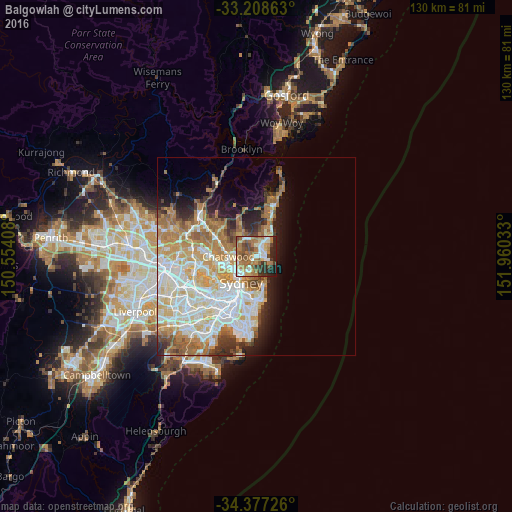
Analysis of Balgowlah night lights 2016
Square area 10x10 km:
 10.14%
90-99
11.36%80-89
5.24%70-79
6.82%60-69
27.27%50-59
9.44%40-49
8.39%30-39
7.34%20-29
9.79%10-19
4.2%0-9
0%Square area 50x50 km:
8.01%90-99
8.44%80-89
4.07%70-79
5.26%60-69
6.82%50-59
3.05%40-49
1.87%30-39
2.86%20-29
3.68%10-19
5.95%0-9
49.99%Clear (daylight) street map image can be seen on geolist.org.
Map coordinates:
33° 12' 31.1" South, 150° 33' 14.7" East
33° 47' 41.8" South, 151° 15' 25.9" East
34° 22' 38.1" South, 151° 57' 37.2" East
Some cities around Balgowlah sort by population:
• Manly
2.9 km =1.8 mi,  96°
96°
• Cremorne
4.5 km =2.8 mi,  218°
218°
• Freshwater
3.2 km =2 mi,  55°
55°
• Seaforth
1.8 km =1.1 mi,  245°
245°
• Allambie Heights
3.2 km =2 mi,  347°
347°
• Northbridge
4.2 km =2.6 mi,  241°
241°
• Manly Vale
1.2 km =0.7 mi,  21°
21°
• Fairlight
1.5 km =0.9 mi,  93°
93°
2177114 (p: 7,768)
Sources (retrieved 2019-11-25):
» Earth at Night: Flat Maps 2012, 2016