Lysterfield night lights from space
Night Light of Lysterfield (Victoria) from space (Australia) Src. Average luminocity for 10x10km area is 35.6429% and for 50x50km: 37.7187%.
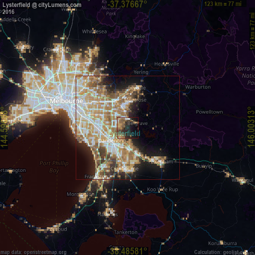
Analysis of Lysterfield night lights 2016
Square area 10x10 km:
 2.44%
2.44%90-99
2.92%80-89
1.79%70-79
6.49%60-69
5.19%50-59
13.96%40-49
8.12%30-39
6.82%20-29
14.45%10-19
19.48%0-9
18.34%Square area 50x50 km:
6.83%90-99
8.06%80-89
4.43%70-79
7.54%60-69
7.35%50-59
5.81%40-49
3.97%30-39
3.33%20-29
4.58%10-19
8.85%0-9
39.25%Clear (daylight) street map image can be seen on geolist.org.
Map coordinates:
37° 22' 36" South, 144° 35' 48.8" East
37° 55' 60" South, 145° 18' 0" East
38° 29' 8.9" South, 146° 0' 11.3" East
Some cities around Lysterfield sort by population:
• Rowville
5.8 km =3.6 mi,  270°
270°
• Ferntree Gully
5.4 km =3.4 mi,  355°
355°
• Endeavour Hills
6.1 km =3.8 mi,  216°
216°
• Boronia
7.6 km =4.7 mi,  348°
348°
• Narre Warren North
5.7 km =3.5 mi,  165°
165°
• Knoxfield
6.6 km =4.1 mi,  317°
317°
• Upwey
4.7 km =2.9 mi,  38°
38°
• Scoresby
6.9 km =4.3 mi,  302°
302°
2159291 (p: 6,569)
Sources (retrieved 2019-11-25):
» Earth at Night: Flat Maps 2012, 2016