Lesmurdie night lights from space
Night Light of Lesmurdie (Western Australia) from space (Australia) Src. Average luminocity for 10x10km area is 36.5874% and for 50x50km: 36.0461%.
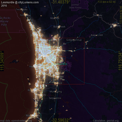
Analysis of Lesmurdie night lights 2016
Square area 10x10 km:
 0.87%
0.87%90-99
1.92%80-89
1.4%70-79
1.05%60-69
14.86%50-59
16.61%40-49
9.97%30-39
12.59%20-29
5.59%10-19
13.29%0-9
21.85%Square area 50x50 km:
8.3%90-99
9.02%80-89
3.95%70-79
5.74%60-69
6.76%50-59
4.23%40-49
3.15%30-39
3.43%20-29
4.19%10-19
5.38%0-9
45.84%Clear (daylight) street map image can be seen on geolist.org.
Map coordinates:
31° 24' 13.6" South, 115° 20' 42.3" East
32° 0' 7.2" South, 116° 2' 53.6" East
32° 35' 46.8" South, 116° 45' 4.8" East
Some cities around Lesmurdie sort by population:
• Forrestfield
4.5 km =2.8 mi,  298°
298°
• High Wycombe
7.7 km =4.8 mi,  326°
326°
• Maddington
8.1 km =5 mi,  228°
228°
• Beckenham
8.7 km =5.4 mi,  253°
253°
• Kalamunda
3.3 km =2.1 mi,  17°
17°
• Wattle Grove
4.5 km =2.8 mi,  263°
263°
• Kenwick
8.4 km =5.2 mi, 245°
• East Cannington
8.8 km =5.5 mi, 264°
8349078 (p: 8,142)
Sources (retrieved 2019-11-25):
» Earth at Night: Flat Maps 2012, 2016