Kalamunda night lights from space
Night Light of Kalamunda (Western Australia) from space (Australia) Src. Average luminocity for 10x10km area is 34.4301% and for 50x50km: 34.9091%.
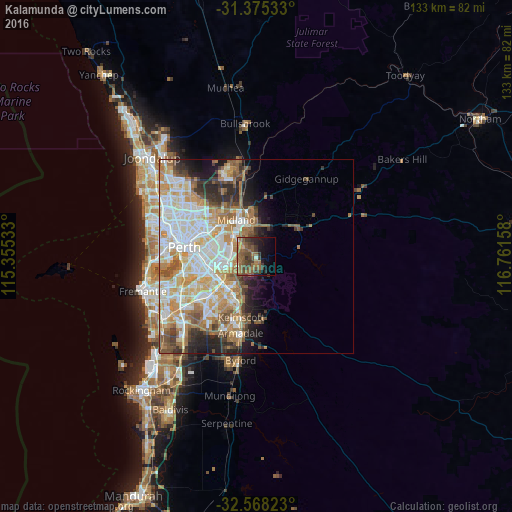
Analysis of Kalamunda night lights 2016
Square area 10x10 km:
 0%
0%90-99
1.92%80-89
0.17%70-79
3.32%60-69
12.76%50-59
15.73%40-49
10.31%30-39
12.76%20-29
4.55%10-19
13.46%0-9
25%Square area 50x50 km:
8.02%90-99
8.77%80-89
3.84%70-79
5.45%60-69
6.42%50-59
4.17%40-49
3.01%30-39
3.46%20-29
4.21%10-19
5.51%0-9
47.14%Clear (daylight) street map image can be seen on geolist.org.
Map coordinates:
31° 22' 31.2" South, 115° 21' 19.2" East
31° 58' 25.4" South, 116° 3' 30.4" East
32° 34' 5.6" South, 116° 45' 41.7" East
Some cities around Kalamunda sort by population:
• Forrestfield
5 km =3.1 mi,  258°
258°
• High Wycombe
6.1 km =3.8 mi,  302°
302°
• Lesmurdie
3.3 km =2.1 mi,  197°
197°
• Swan View
10.1 km =6.3 mi,  355°
355°
• Kewdale
10.1 km =6.3 mi,  266°
266°
• Midland
10.4 km =6.5 mi,  334°
334°
• Wattle Grove
6.6 km =4.1 mi,  236°
236°
• East Cannington
10.5 km =6.5 mi,  247°
247°
11695435 (p: 6,744)
Sources (retrieved 2019-11-25):
» Earth at Night: Flat Maps 2012, 2016