Maddington night lights from space
Night Light of Maddington (Western Australia) from space (Australia) Src. Average luminocity for 10x10km area is 72.6993% and for 50x50km: 40.7407%.
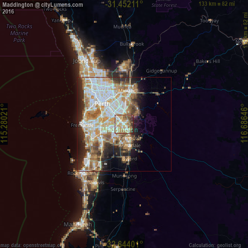
Analysis of Maddington night lights 2016
Square area 10x10 km:
 10.31%
90-99
15.73%80-89
12.06%70-79
21.5%60-69
16.78%50-59
8.22%40-49
5.42%30-39
5.42%20-29
4.55%10-19
0%0-9
0%Square area 50x50 km:
9.23%90-99
9.87%80-89
4.58%70-79
5.9%60-69
8.17%50-59
4.78%40-49
3.52%30-39
3.43%20-29
6.34%10-19
7.41%0-9
36.75%Clear (daylight) street map image can be seen on geolist.org.
Map coordinates:
31° 27' 7.6" South, 115° 16' 48.8" East
32° 3' 0" South, 115° 58' 60" East
32° 38' 38.4" South, 116° 41' 11.3" East
Some cities around Maddington sort by population:
• Thornlie
2.9 km =1.8 mi,  247°
247°
• Gosnells
4 km =2.5 mi,  148°
148°
• Huntingdale
4 km =2.5 mi,  203°
203°
• Beckenham
3.6 km =2.2 mi,  321°
321°
• Wattle Grove
5.1 km =3.2 mi,  18°
18°
• Kenwick
2.4 km =1.5 mi, 319°
• Langford
4.1 km =2.5 mi,  284°
284°
• East Cannington
5.2 km =3.2 mi,  329°
329°
2067260 (p: 11,198)
Sources (retrieved 2019-11-25):
» Earth at Night: Flat Maps 2012, 2016