Lara night lights from space
Night Light of Lara (Victoria) from space (Australia) Src. Average luminocity for 10x10km area is 18.4383% and for 50x50km: 8.8933%.
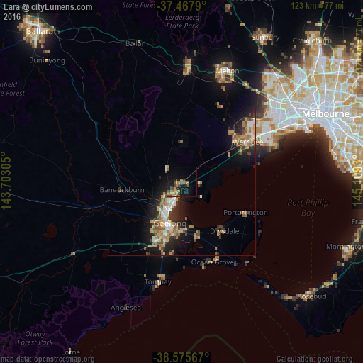
Analysis of Lara night lights 2016
Square area 10x10 km:
 0.49%
0.49%90-99
0.32%80-89
0.49%70-79
4.38%60-69
6.01%50-59
3.73%40-49
4.55%30-39
0.97%20-29
4.06%10-19
18.18%0-9
56.82%Square area 50x50 km:
0.93%90-99
1%80-89
0.56%70-79
2.06%60-69
1.57%50-59
1.42%40-49
1.53%30-39
1.13%20-29
2.52%10-19
6.19%0-9
81.09%Clear (daylight) street map image can be seen on geolist.org.
Map coordinates:
37° 28' 4.4" South, 143° 42' 11" East
38° 1' 26" South, 144° 24' 22.2" East
38° 34' 32.4" South, 145° 6' 33.5" East
Some cities around Lara sort by population:
• Geelong
14.3 km =8.9 mi,  196°
196°
• Corio
6.9 km =4.3 mi, 196°
• Belmont
17.7 km =11 mi, 198°
• Newtown
15.7 km =9.8 mi, 203°
• Norlane
9.7 km =6 mi,  207°
207°
• Geelong West
13.7 km =8.5 mi, 201°
• Hamlyn Heights
12.8 km =8 mi, 212°
• Geelong city centre
14.5 km =9 mi, 195°
2160560 (p: 15,919)
Sources (retrieved 2019-11-25):
» Earth at Night: Flat Maps 2012, 2016