Hawthorn South night lights from space
Night Light of Hawthorn South (Victoria) from space (Australia) Src. Average luminocity for 10x10km area is 94.4371% and for 50x50km: 55.6651%.
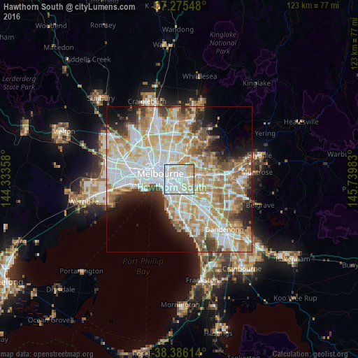

Analysis of Hawthorn South night lights 2016
Square area 10x10 km:
 46.43%
90-99
29.42%80-89
12.76%70-79
11.05%60-69
0.34%50-59
0%40-49
0%30-39
0%20-29
0%10-19
0%0-9
0%Square area 50x50 km:
15.14%90-99
13.94%80-89
7.09%70-79
9.62%60-69
8.39%50-59
5.65%40-49
3.74%30-39
3.5%20-29
5.21%10-19
6.19%0-9
21.53%Clear (daylight) street map image can be seen on geolist.org.
Map coordinates:
37° 16' 31.7" South, 144° 20' 0.9" East
37° 49' 58.4" South, 145° 2' 12.1" East
38° 23' 10.1" South, 145° 44' 23.4" East
Some cities around Hawthorn South sort by population:
• Richmond
3.5 km =2.2 mi,  298°
298°
• South Yarra
4 km =2.5 mi,  261°
261°
• Kew
3 km =1.9 mi,  350°
350°
• Camberwell
3 km =1.9 mi,  109°
109°
• Glenferrie
1.2 km =0.7 mi,  92°
92°
• Toorak
2.2 km =1.4 mi,  243°
243°
• Malvern
3.4 km =2.1 mi,  192°
192°
• Armadale
2.9 km =1.8 mi,  209°
209°
2163776 (p: 21,177)
Sources (retrieved 2019-11-25):
» Earth at Night: Flat Maps 2012, 2016