Malvern night lights from space
Night Light of Malvern (Victoria) from space (Australia) Src. Average luminocity for 10x10km area is 94.4432% and for 50x50km: 55.7307%.
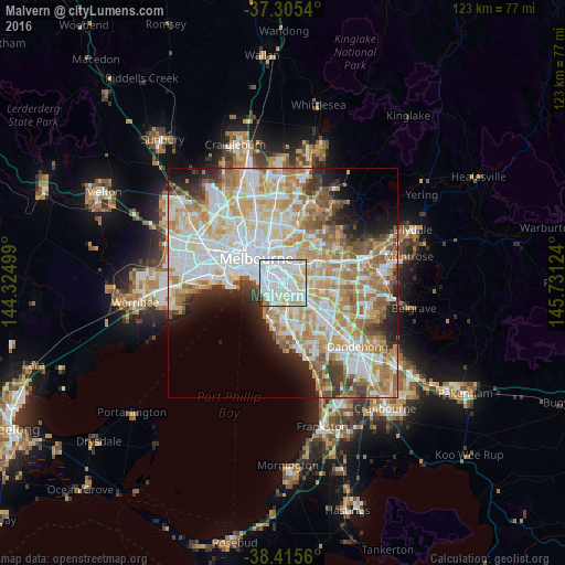
Analysis of Malvern night lights 2016
Square area 10x10 km:
 49.51%
90-99
30.03%80-89
12.01%70-79
4.87%60-69
0.81%50-59
1.46%40-49
0%30-39
1.3%20-29
0%10-19
0%0-9
0%Square area 50x50 km:
15.51%90-99
14.07%80-89
7.19%70-79
9.45%60-69
8.46%50-59
5.45%40-49
3.67%30-39
3.2%20-29
4.77%10-19
5.83%0-9
22.41%Clear (daylight) street map image can be seen on geolist.org.
Map coordinates:
37° 18' 19.4" South, 144° 19' 30" East
37° 51' 45.3" South, 145° 1' 41.2" East
38° 24' 56.2" South, 145° 43' 52.5" East
Some cities around Malvern sort by population:
• Caulfield North
1.3 km =0.8 mi,  192°
192°
• St Kilda East
2.5 km =1.6 mi,  261°
261°
• Prahran
3.3 km =2.1 mi,  292°
292°
• Toorak
2.6 km =1.6 mi,  332°
332°
• Armadale
1 km =0.6 mi,  320°
320°
• Windsor
3.3 km =2.1 mi, 287°
• Caulfield
2.3 km =1.4 mi, 191°
• Balaclava
2.5 km =1.6 mi, 259°
2158952 (p: 10,143)
Sources (retrieved 2019-11-25):
» Earth at Night: Flat Maps 2012, 2016