South Yarra night lights from space
Night Light of South Yarra (Victoria) from space (Australia) Src. Average luminocity for 10x10km area is 93.3163% and for 50x50km: 55.792%.
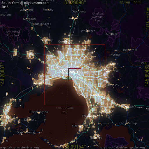

Analysis of South Yarra night lights 2016
Square area 10x10 km:
 64.29%
90-99
21.6%80-89
3.74%70-79
0.85%60-69
0%50-59
2.21%40-49
3.06%30-39
4.08%20-29
0.17%10-19
0%0-9
0%Square area 50x50 km:
15.58%90-99
14.28%80-89
7.19%70-79
9.44%60-69
8.05%50-59
5.1%40-49
3.53%30-39
3.61%20-29
4.92%10-19
6.5%0-9
21.8%Clear (daylight) street map image can be seen on geolist.org.
Map coordinates:
37° 16' 51.5" South, 144° 17' 18.1" East
37° 50' 18" South, 144° 59' 29.4" East
38° 23' 29.5" South, 145° 41' 40.6" East
Some cities around South Yarra sort by population:
• Richmond
2.4 km =1.5 mi,  21°
21°
• St Kilda East
3.2 km =2 mi,  166°
166°
• Prahran
1.4 km =0.9 mi, 174°
• Toorak
2 km =1.2 mi,  100°
100°
• Armadale
3.2 km =2 mi,  126°
126°
• Windsor
1.7 km =1.1 mi,  177°
177°
• East Melbourne
2.4 km =1.5 mi,  352°
352°
• Balaclava
3.2 km =2 mi, 166°
2148876 (p: 25,237)
Sources (retrieved 2019-11-25):
» Earth at Night: Flat Maps 2012, 2016