Granville night lights from space
Night Light of Granville (New South Wales) from space (Australia) Src. Average luminocity for 10x10km area is 96.2692% and for 50x50km: 59.5168%.

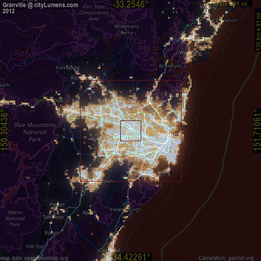
Analysis of Granville night lights 2016
Square area 10x10 km:
 41.78%
90-99
43.18%80-89
13.29%70-79
1.75%60-69
0%50-59
0%40-49
0%30-39
0%20-29
0%10-19
0%0-9
0%Square area 50x50 km:
13.79%90-99
14.91%80-89
7.69%70-79
9.47%60-69
10.95%50-59
5.87%40-49
4.24%30-39
5.88%20-29
7.74%10-19
9.12%0-9
10.34%Clear (daylight) street map image can be seen on geolist.org.
Map coordinates:
33° 15' 16.6" South, 150° 18' 15.7" East
33° 50' 26.2" South, 151° 0' 26.9" East
34° 25' 21.4" South, 151° 42' 38.2" East
Some cities around Granville sort by population:
• Auburn
2.6 km =1.6 mi,  113°
113°
• Merrylands
2.4 km =1.5 mi,  289°
289°
• Parramatta
2.6 km =1.6 mi,  351°
351°
• Lidcombe
4 km =2.5 mi,  131°
131°
• Rydalmere
4 km =2.5 mi,  43°
43°
• Merrylands West
3.7 km =2.3 mi,  283°
283°
• Harris Park
2 km =1.2 mi,  0°
0°
• South Granville
2 km =1.2 mi,  171°
171°
2164691 (p: 22,889)
Sources (retrieved 2019-11-25):
» Earth at Night: Flat Maps 2012, 2016