Rydalmere night lights from space
Night Light of Rydalmere (New South Wales) from space (Australia) Src. Average luminocity for 10x10km area is 91.4283% and for 50x50km: 58.193%.
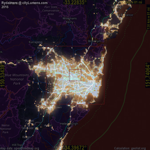
Analysis of Rydalmere night lights 2016
Square area 10x10 km:
 33.39%
90-99
31.12%80-89
15.21%70-79
19.23%60-69
1.05%50-59
0%40-49
0%30-39
0%20-29
0%10-19
0%0-9
0%Square area 50x50 km:
13.44%90-99
14.92%80-89
7.68%70-79
9.44%60-69
10.49%50-59
5.36%40-49
3.93%30-39
5.54%20-29
7.59%10-19
8.65%0-9
12.96%Clear (daylight) street map image can be seen on geolist.org.
Map coordinates:
33° 13' 42.1" South, 150° 20' 3.8" East
33° 48' 52.3" South, 151° 2' 15" East
34° 23' 48.2" South, 151° 44' 26.3" East
Some cities around Rydalmere sort by population:
• Parramatta
3.2 km =2 mi,  263°
263°
• West Ryde
3.5 km =2.2 mi,  73°
73°
• Ermington
1.6 km =1 mi,  91°
91°
• Newington
2.9 km =1.8 mi,  141°
141°
• Harris Park
2.9 km =1.8 mi,  251°
251°
• Oatlands
2.3 km =1.4 mi,  335°
335°
• Telopea
2.4 km =1.5 mi,  2°
2°
• Dundas Valley
3.2 km =2 mi,  25°
25°
2150768 (p: 6,571)
Sources (retrieved 2019-11-25):
» Earth at Night: Flat Maps 2012, 2016