Goodna night lights from space
Night Light of Goodna (Queensland) from space (Australia) Src. Average luminocity for 10x10km area is 70.754% and for 50x50km: 35.4918%.
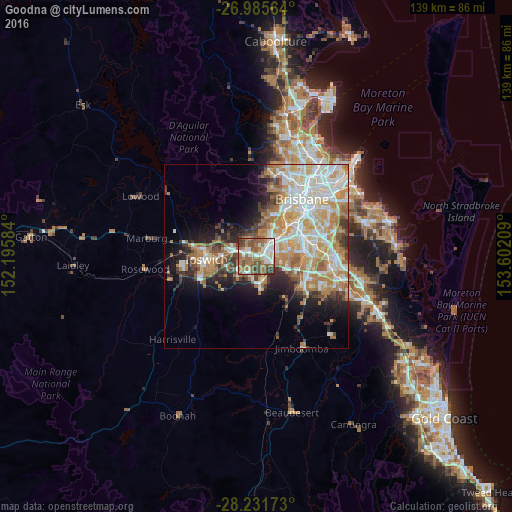
Analysis of Goodna night lights 2016
Square area 10x10 km:
 15.67%
90-99
16.27%80-89
3.17%70-79
2.38%60-69
28.77%50-59
17.66%40-49
9.72%30-39
5.56%20-29
0.79%10-19
0%0-9
0%Square area 50x50 km:
7.42%90-99
8.1%80-89
4.34%70-79
5.12%60-69
8.69%50-59
2.97%40-49
3.32%30-39
3.32%20-29
4.57%10-19
7.89%0-9
44.25%Clear (daylight) street map image can be seen on geolist.org.
Map coordinates:
26° 59' 8.3" South, 152° 11' 45" East
27° 36' 37.7" South, 152° 53' 56.3" East
28° 13' 54.2" South, 153° 36' 7.5" East
Some cities around Goodna sort by population:
• Forest Lake
7.1 km =4.4 mi,  103°
103°
• Redbank Plains
5.5 km =3.4 mi,  224°
224°
• Springfield Lakes
6.8 km =4.2 mi,  158°
158°
• Camira
3.4 km =2.1 mi,  141°
141°
• Collingwood Park
3.8 km =2.4 mi,  266°
266°
• Springfield
5.1 km =3.2 mi, 159°
• Bellbird Park
3.2 km =2 mi,  202°
202°
• Bellbowrie
5.9 km =3.7 mi,  344°
344°
2165025 (p: 10,432)
Sources (retrieved 2019-11-25):
» Earth at Night: Flat Maps 2012, 2016