Camira night lights from space
Night Light of Camira (Queensland) from space (Australia) Src. Average luminocity for 10x10km area is 66.4504% and for 50x50km: 35.1953%.
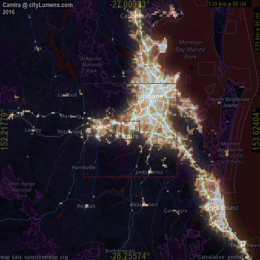
Analysis of Camira night lights 2016
Square area 10x10 km:
 14.48%
90-99
13.29%80-89
5.95%70-79
5.95%60-69
23.21%50-59
10.52%40-49
8.13%30-39
8.33%20-29
9.92%10-19
0.2%0-9
0%Square area 50x50 km:
7.12%90-99
7.74%80-89
4.09%70-79
5.04%60-69
9.03%50-59
3.1%40-49
3.59%30-39
3.51%20-29
5.31%10-19
7.93%0-9
43.54%Clear (daylight) street map image can be seen on geolist.org.
Map coordinates:
27° 0' 35.7" South, 152° 13' 4" East
27° 38' 4.6" South, 152° 55' 15.3" East
28° 15' 20.7" South, 153° 37' 26.5" East
Some cities around Camira sort by population:
• Forest Lake
4.8 km =3 mi,  78°
78°
• Redbank Plains
6.2 km =3.9 mi,  258°
258°
• Springfield Lakes
3.7 km =2.3 mi,  173°
173°
• Inala
6.7 km =4.2 mi,  51°
51°
• Goodna
3.4 km =2.1 mi,  321°
321°
• Collingwood Park
6.5 km =4 mi,  292°
292°
• Springfield
2.1 km =1.3 mi,  189°
189°
• Bellbird Park
3.4 km =2.1 mi,  265°
265°
8349242 (p: 7,282)
Sources (retrieved 2019-11-25):
» Earth at Night: Flat Maps 2012, 2016