Bellbowrie night lights from space
Night Light of Bellbowrie (Queensland) from space (Australia) Src. Average luminocity for 10x10km area is 46.0238% and for 50x50km: 37.1571%.
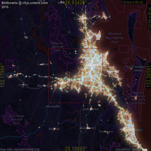
Analysis of Bellbowrie night lights 2016
Square area 10x10 km:
 6.15%
6.15%90-99
6.15%80-89
0.4%70-79
2.58%60-69
16.27%50-59
14.29%40-49
10.71%30-39
7.74%20-29
12.3%10-19
16.27%0-9
7.14%Square area 50x50 km:
7.78%90-99
8.55%80-89
4.72%70-79
5.57%60-69
8.85%50-59
2.95%40-49
3.33%30-39
3.29%20-29
4.99%10-19
8.25%0-9
41.73%Clear (daylight) street map image can be seen on geolist.org.
Map coordinates:
26° 56' 3.4" South, 152° 10' 46.8" East
27° 33' 33.8" South, 152° 52' 58" East
28° 10' 51.4" South, 153° 35' 9.3" East
Some cities around Bellbowrie sort by population:
• Goodna
5.9 km =3.7 mi,  164°
164°
• Chapel Hill
9.2 km =5.7 mi,  46°
46°
• Kenmore
8 km =5 mi,  43°
43°
• Camira
9.2 km =5.7 mi, 155°
• Collingwood Park
6.3 km =3.9 mi,  200°
200°
• Bundamba
9 km =5.6 mi,  231°
231°
• Sinnamon Park
6.7 km =4.2 mi,  75°
75°
• Jindalee
6.1 km =3.8 mi,  63°
63°
8348635 (p: 5,366)
Sources (retrieved 2019-11-25):
» Earth at Night: Flat Maps 2012, 2016