Redbank Plains night lights from space
Night Light of Redbank Plains (Queensland) from space (Australia) Src. Average luminocity for 10x10km area is 54.879% and for 50x50km: 28.868%.
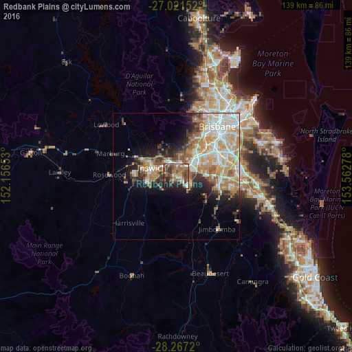
Analysis of Redbank Plains night lights 2016
Square area 10x10 km:
 7.14%
7.14%90-99
7.94%80-89
2.38%70-79
1.79%60-69
27.58%50-59
10.71%40-49
13.69%30-39
9.13%20-29
10.32%10-19
9.33%0-9
0%Square area 50x50 km:
5.8%90-99
6.43%80-89
3.36%70-79
4.08%60-69
7.19%50-59
2.56%40-49
2.73%30-39
2.88%20-29
4.27%10-19
7.29%0-9
53.39%Clear (daylight) street map image can be seen on geolist.org.
Map coordinates:
27° 1' 17.5" South, 152° 9' 23.5" East
27° 38' 46.1" South, 152° 51' 34.7" East
28° 16' 1.9" South, 153° 33' 46" East
Some cities around Redbank Plains sort by population:
• Springfield Lakes
6.9 km =4.3 mi,  110°
110°
• Goodna
5.5 km =3.4 mi,  44°
44°
• Camira
6.2 km =3.9 mi,  78°
78°
• Collingwood Park
3.7 km =2.3 mi,  0°
0°
• Springfield
5.7 km =3.5 mi,  98°
98°
• Bellbird Park
2.9 km =1.8 mi,  68°
68°
• Bundamba
6.3 km =3.9 mi,  310°
310°
• Flinders View
8.4 km =5.2 mi,  266°
266°
7932670 (p: 19,094)
Sources (retrieved 2019-11-25):
» Earth at Night: Flat Maps 2012, 2016