Glenhaven night lights from space
Night Light of Glenhaven (New South Wales) from space (Australia) Src. Average luminocity for 10x10km area is 51.6667% and for 50x50km: 42.6359%.
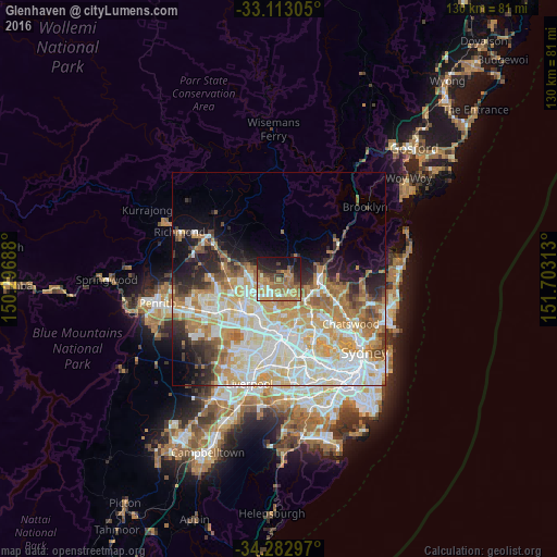
Analysis of Glenhaven night lights 2016
Square area 10x10 km:
 4.76%
4.76%90-99
4.76%80-89
5.86%70-79
13.55%60-69
19.05%50-59
8.42%40-49
6.96%30-39
4.76%20-29
12.64%10-19
17.77%0-9
1.47%Square area 50x50 km:
10.15%90-99
10.96%80-89
5.92%70-79
7.4%60-69
7.35%50-59
3.11%40-49
2.63%30-39
3.45%20-29
4.83%10-19
6.68%0-9
37.52%Clear (daylight) street map image can be seen on geolist.org.
Map coordinates:
33° 6' 47" South, 150° 17' 48.8" East
33° 42' 0" South, 151° 0' 0" East
34° 16' 58.7" South, 151° 42' 11.3" East
Some cities around Glenhaven sort by population:
• Castle Hill
3.7 km =2.3 mi,  180°
180°
• Baulkham Hills
6.6 km =4.1 mi,  185°
185°
• Kellyville
4.7 km =2.9 mi,  255°
255°
• Cherrybrook
4.9 km =3 mi,  119°
119°
• West Pennant Hills
6.7 km =4.2 mi,  139°
139°
• Beaumont Hills
5.4 km =3.4 mi,  270°
270°
• Bella Vista
6.2 km =3.9 mi,  222°
222°
• Dural
2.4 km =1.5 mi,  39°
39°
2165303 (p: 6,402)
Sources (retrieved 2019-11-25):
» Earth at Night: Flat Maps 2012, 2016