Dural night lights from space
Night Light of Dural (New South Wales) from space (Australia) Src. Average luminocity for 10x10km area is 34.6703% and for 50x50km: 40.3639%.
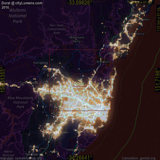
Analysis of Dural night lights 2016
Square area 10x10 km:
 0.73%
0.73%90-99
1.1%80-89
1.47%70-79
6.78%60-69
13.74%50-59
8.42%40-49
6.96%30-39
6.41%20-29
15.57%10-19
21.61%0-9
17.22%Square area 50x50 km:
9.21%90-99
10.19%80-89
5.34%70-79
7.2%60-69
7.48%50-59
3.21%40-49
2.54%30-39
3.47%20-29
4.73%10-19
6.42%0-9
40.2%Clear (daylight) street map image can be seen on geolist.org.
Map coordinates:
33° 5' 46.5" South, 150° 18' 48.8" East
33° 40' 60" South, 151° 1' 0" East
34° 15' 59.1" South, 151° 43' 11.3" East
Some cities around Dural sort by population:
• Castle Hill
5.8 km =3.6 mi,  195°
195°
• Kellyville
6.8 km =4.2 mi,  243°
243°
• Hornsby
7.9 km =4.9 mi,  105°
105°
• Cherrybrook
5.1 km =3.2 mi,  147°
147°
• West Pennant Hills
7.5 km =4.7 mi,  157°
157°
• Beaumont Hills
7.2 km =4.5 mi,  255°
255°
• Glenhaven
2.4 km =1.5 mi,  219°
219°
• Hornsby Heights
7.3 km =4.5 mi,  79°
79°
2168041 (p: 7,493)
Sources (retrieved 2019-11-25):
» Earth at Night: Flat Maps 2012, 2016