Everton Hills night lights from space
Night Light of Everton Hills (Queensland) from space (Australia) Src. Average luminocity for 10x10km area is 68.5455% and for 50x50km: 38.2253%.
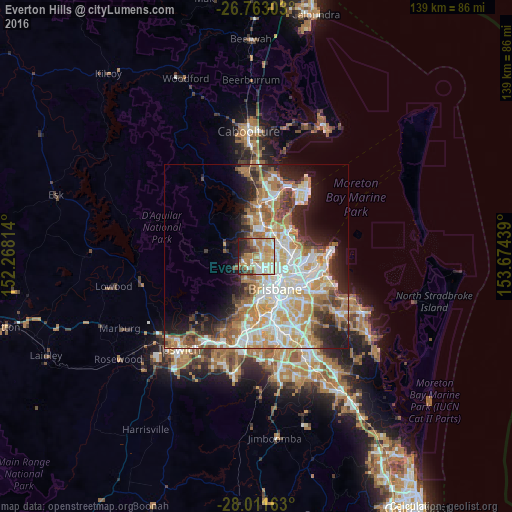
Analysis of Everton Hills night lights 2016
Square area 10x10 km:
 9.66%
9.66%90-99
12.69%80-89
16.29%70-79
14.2%60-69
18.37%50-59
3.98%40-49
8.14%30-39
5.11%20-29
8.71%10-19
2.84%0-9
0%Square area 50x50 km:
7.95%90-99
8.68%80-89
5.06%70-79
5.22%60-69
9.13%50-59
2.87%40-49
3.86%30-39
3.83%20-29
6.02%10-19
8.64%0-9
38.72%Clear (daylight) street map image can be seen on geolist.org.
Map coordinates:
26° 45' 46.9" South, 152° 16' 5.3" East
27° 23' 20.7" South, 152° 58' 16.5" East
28° 0' 41.9" South, 153° 40' 27.8" East
Some cities around Everton Hills sort by population:
• Albany Creek
4 km =2.5 mi,  356°
356°
• Ferny Hills
3.4 km =2.1 mi,  257°
257°
• Mitchelton
3.1 km =1.9 mi,  188°
188°
• McDowall
2.2 km =1.4 mi,  70°
70°
• Keperra
3.6 km =2.2 mi,  221°
221°
• Stafford Heights
3.9 km =2.4 mi,  97°
97°
• Arana Hills
1.6 km =1 mi,  232°
232°
• Ferny Grove
3.8 km =2.4 mi,  250°
250°
8348461 (p: 5,833)
Sources (retrieved 2019-11-25):
» Earth at Night: Flat Maps 2012, 2016