McDowall night lights from space
Night Light of McDowall (Queensland) from space (Australia) Src. Average luminocity for 10x10km area is 79.464% and for 50x50km: 38.1045%.
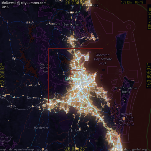
Analysis of McDowall night lights 2016
Square area 10x10 km:
 14.58%
90-99
19.7%80-89
21.97%70-79
14.02%60-69
17.42%50-59
3.22%40-49
5.11%30-39
2.65%20-29
1.33%10-19
0%0-9
0%Square area 50x50 km:
7.83%90-99
8.52%80-89
5.01%70-79
5.15%60-69
9.21%50-59
2.91%40-49
3.99%30-39
3.89%20-29
6.13%10-19
8.9%0-9
38.44%Clear (daylight) street map image can be seen on geolist.org.
Map coordinates:
26° 45' 23.6" South, 152° 17' 19.8" East
27° 22' 57.6" South, 152° 59' 31" East
28° 0' 18.8" South, 153° 41' 42.3" East
Some cities around McDowall sort by population:
• Aspley
3 km =1.9 mi,  53°
53°
• Chermside
3.8 km =2.4 mi,  93°
93°
• Everton Park
2.8 km =1.7 mi,  187°
187°
• Bridgeman Downs
3 km =1.9 mi,  4°
4°
• Stafford Heights
2.2 km =1.4 mi,  123°
123°
• Stafford
3.6 km =2.2 mi,  148°
148°
• Chermside West
2.4 km =1.5 mi, 93°
• Everton Hills
2.2 km =1.4 mi,  250°
250°
8348883 (p: 7,108)
Sources (retrieved 2019-11-25):
» Earth at Night: Flat Maps 2012, 2016