Stafford Heights night lights from space
Night Light of Stafford Heights (Queensland) from space (Australia) Src. Average luminocity for 10x10km area is 87.6231% and for 50x50km: 39.4271%.
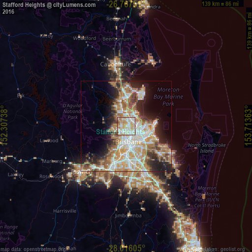
Analysis of Stafford Heights night lights 2016
Square area 10x10 km:
 21.59%
90-99
27.84%80-89
27.65%70-79
11.74%60-69
8.71%50-59
1.7%40-49
0.76%30-39
0%20-29
0%10-19
0%0-9
0%Square area 50x50 km:
8.04%90-99
8.75%80-89
5.21%70-79
5.46%60-69
9.68%50-59
3.07%40-49
4.05%30-39
3.94%20-29
6.36%10-19
9.02%0-9
36.41%Clear (daylight) street map image can be seen on geolist.org.
Map coordinates:
26° 46' 3" South, 152° 18' 26.6" East
27° 23' 36.7" South, 153° 0' 37.8" East
28° 0' 57.8" South, 153° 42' 49.1" East
Some cities around Stafford Heights sort by population:
• Aspley
3 km =1.9 mi,  11°
11°
• Chermside
2.2 km =1.4 mi,  63°
63°
• Wavell Heights
3.6 km =2.2 mi,  90°
90°
• Kedron
2.2 km =1.4 mi,  118°
118°
• Everton Park
2.7 km =1.7 mi,  234°
234°
• McDowall
2.2 km =1.4 mi,  303°
303°
• Chermside West
1.2 km =0.7 mi,  26°
26°
• Alderley
3.7 km =2.3 mi,  194°
194°
9957328 (p: 6,702)
Sources (retrieved 2019-11-25):
» Earth at Night: Flat Maps 2012, 2016