Keperra night lights from space
Night Light of Keperra (Queensland) from space (Australia) Src. Average luminocity for 10x10km area is 56.5284% and for 50x50km: 40.5142%.
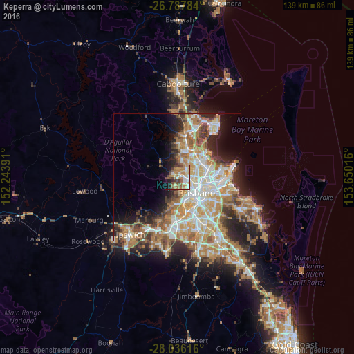
Analysis of Keperra night lights 2016
Square area 10x10 km:
 6.82%
6.82%90-99
9.85%80-89
8.9%70-79
8.71%60-69
20.08%50-59
5.3%40-49
8.71%30-39
5.3%20-29
6.63%10-19
18.18%0-9
1.52%Square area 50x50 km:
8.49%90-99
9.15%80-89
5.34%70-79
5.75%60-69
9.87%50-59
3.56%40-49
4.07%30-39
3.74%20-29
6%10-19
7.35%0-9
36.69%Clear (daylight) street map image can be seen on geolist.org.
Map coordinates:
26° 47' 16.2" South, 152° 14' 38.1" East
27° 24' 49.5" South, 152° 56' 49.3" East
28° 2' 10.2" South, 153° 39' 0.6" East
Some cities around Keperra sort by population:
• The Gap
3.2 km =2 mi,  194°
194°
• Everton Park
4.1 km =2.5 mi,  80°
80°
• Ferny Hills
2.2 km =1.4 mi,  334°
334°
• Mitchelton
2 km =1.2 mi,  99°
99°
• Arana Hills
2.1 km =1.3 mi,  31°
31°
• Everton Hills
3.6 km =2.2 mi,  41°
41°
• Ferny Grove
1.9 km =1.2 mi,  319°
319°
• Enoggera
3.2 km =2 mi,  120°
120°
6943584 (p: 6,735)
Sources (retrieved 2019-11-25):
» Earth at Night: Flat Maps 2012, 2016