Lalor night lights from space
Night Light of Lalor (Victoria) from space (Australia) Src. Average luminocity for 10x10km area is 79.7398% and for 50x50km: 44.3843%.
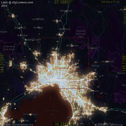

Analysis of Lalor night lights 2016
Square area 10x10 km:
 17.69%
90-99
20.58%80-89
11.9%70-79
19.73%60-69
17.35%50-59
6.8%40-49
3.74%30-39
2.21%20-29
0%10-19
0%0-9
0%Square area 50x50 km:
12.82%90-99
11.03%80-89
5.74%70-79
7.18%60-69
6.22%50-59
3.86%40-49
3.09%30-39
2.69%20-29
4.01%10-19
5.74%0-9
37.62%Clear (daylight) street map image can be seen on geolist.org.
Map coordinates:
37° 6' 28.8" South, 144° 18' 48.8" East
37° 40' 0" South, 145° 1' 0" East
38° 13' 16.2" South, 145° 43' 11.3" East
Some cities around Lalor sort by population:
• Reservoir
5.7 km =3.5 mi,  194°
194°
• Epping
2.4 km =1.5 mi,  38°
38°
• Mill Park
4.4 km =2.7 mi,  90°
90°
• Bundoora
5.2 km =3.2 mi,  132°
132°
• Thomastown
1.9 km =1.2 mi,  180°
180°
• Fawkner
7.1 km =4.4 mi,  218°
218°
• Dallas
7.2 km =4.5 mi,  266°
266°
• Campbellfield
5 km =3.1 mi, 273°
2160706 (p: 22,413)
Sources (retrieved 2019-11-25):
» Earth at Night: Flat Maps 2012, 2016