Earlwood night lights from space
Night Light of Earlwood (New South Wales) from space (Australia) Src. Average luminocity for 10x10km area is 94.2483% and for 50x50km: 48.7325%.
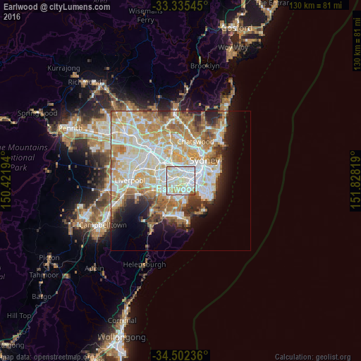
Analysis of Earlwood night lights 2016
Square area 10x10 km:
 37.41%
90-99
38.99%80-89
19.06%70-79
2.45%60-69
1.22%50-59
0.87%40-49
0%30-39
0%20-29
0%10-19
0%0-9
0%Square area 50x50 km:
12.08%90-99
13.18%80-89
6.99%70-79
7.98%60-69
8.11%50-59
4.05%40-49
2.46%30-39
3.21%20-29
4.34%10-19
6.47%0-9
31.15%Clear (daylight) street map image can be seen on geolist.org.
Map coordinates:
33° 20' 7.6" South, 150° 25' 19" East
33° 55' 15.2" South, 151° 7' 30.2" East
34° 30' 8.5" South, 151° 49' 41.5" East
Some cities around Earlwood sort by population:
• Marrickville
3.2 km =2 mi,  61°
61°
• Campsie
2.3 km =1.4 mi,  294°
294°
• Rockdale
3.3 km =2.1 mi,  166°
166°
• Dulwich Hill
2.3 km =1.4 mi,  35°
35°
• Kingsgrove
3.1 km =1.9 mi,  229°
229°
• Arncliffe
2.7 km =1.7 mi,  128°
128°
• Canterbury
1.2 km =0.7 mi,  329°
329°
• Wolli Creek
2.8 km =1.7 mi,  114°
114°
2167949 (p: 17,592)
Sources (retrieved 2019-11-25):
» Earth at Night: Flat Maps 2012, 2016