Carseldine night lights from space
Night Light of Carseldine (Queensland) from space (Australia) Src. Average luminocity for 10x10km area is 83.2254% and for 50x50km: 34.1345%.
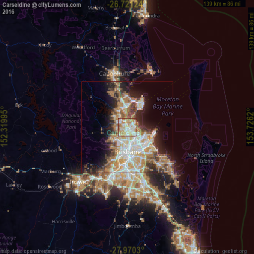
Analysis of Carseldine night lights 2016
Square area 10x10 km:
 19.32%
90-99
22.35%80-89
17.05%70-79
18.18%60-69
18.18%50-59
3.98%40-49
0.38%30-39
0.38%20-29
0.19%10-19
0%0-9
0%Square area 50x50 km:
6.65%90-99
7.36%80-89
4.39%70-79
4.46%60-69
8.69%50-59
2.66%40-49
3.7%30-39
3.89%20-29
5.68%10-19
9.05%0-9
43.46%Clear (daylight) street map image can be seen on geolist.org.
Map coordinates:
26° 43' 16.5" South, 152° 19' 11.8" East
27° 20' 51.1" South, 153° 1' 23.1" East
27° 58' 13.1" South, 153° 43' 34.3" East
Some cities around Carseldine sort by population:
• Bracken Ridge
3.5 km =2.2 mi,  12°
12°
• Aspley
2.2 km =1.4 mi,  196°
196°
• Boondall
3.8 km =2.4 mi,  99°
99°
• Zillmere
2.3 km =1.4 mi,  113°
113°
• Bridgeman Downs
3 km =1.9 mi,  252°
252°
• Taigum
2.2 km =1.4 mi,  75°
75°
• Bald Hills
3.3 km =2.1 mi,  334°
334°
• Fitzgibbon
1.1 km =0.7 mi,  34°
34°
6943557 (p: 9,417)
Sources (retrieved 2019-11-25):
» Earth at Night: Flat Maps 2012, 2016