Bracken Ridge night lights from space
Night Light of Bracken Ridge (Queensland) from space (Australia) Src. Average luminocity for 10x10km area is 72.1856% and for 50x50km: 31.0674%.
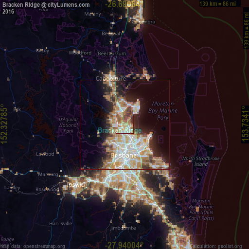
Analysis of Bracken Ridge night lights 2016
Square area 10x10 km:
 13.64%
90-99
14.58%80-89
10.8%70-79
10.8%60-69
25.57%50-59
10.61%40-49
6.44%30-39
2.84%20-29
4.73%10-19
0%0-9
0%Square area 50x50 km:
5.98%90-99
6.66%80-89
3.97%70-79
3.78%60-69
8.12%50-59
2.46%40-49
3.21%30-39
3.6%20-29
5.04%10-19
9.16%0-9
48.03%Clear (daylight) street map image can be seen on geolist.org.
Map coordinates:
26° 41' 26.3" South, 152° 19' 40.3" East
27° 19' 1.6" South, 153° 1' 51.5" East
27° 56' 24.1" South, 153° 44' 2.8" East
Some cities around Bracken Ridge sort by population:
• Carseldine
3.5 km =2.2 mi,  192°
192°
• Brighton
3.5 km =2.2 mi,  47°
47°
• Strathpine
4.3 km =2.7 mi,  289°
289°
• Boondall
5 km =3.1 mi,  143°
143°
• Zillmere
4.5 km =2.8 mi,  162°
162°
• Taigum
3.1 km =1.9 mi,  154°
154°
• Bald Hills
2.3 km =1.4 mi,  258°
258°
• Fitzgibbon
2.5 km =1.6 mi,  183°
183°
6943558 (p: 16,701)
Sources (retrieved 2019-11-25):
» Earth at Night: Flat Maps 2012, 2016