St Johns Park night lights from space
Night Light of St Johns Park (New South Wales) from space (Australia) Src. Average luminocity for 10x10km area is 89.0087% and for 50x50km: 54.3586%.
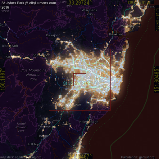
Analysis of St Johns Park night lights 2016
Square area 10x10 km:
 27.27%
90-99
32.34%80-89
14.86%70-79
15.91%60-69
6.29%50-59
3.32%40-49
0%30-39
0%20-29
0%10-19
0%0-9
0%Square area 50x50 km:
11.52%90-99
13.25%80-89
7.48%70-79
9.17%60-69
10.18%50-59
5.43%40-49
3.88%30-39
5.55%20-29
7.27%10-19
10.11%0-9
16.15%Clear (daylight) street map image can be seen on geolist.org.
Map coordinates:
33° 17' 50.1" South, 150° 11' 55.3" East
33° 52' 58.6" South, 150° 54' 6.6" East
34° 27' 52.8" South, 151° 36' 17.8" East
Some cities around St Johns Park sort by population:
• Bossley Park
2.9 km =1.8 mi,  325°
325°
• Fairfield West
2.3 km =1.4 mi,  37°
37°
• Canley Heights
2.1 km =1.3 mi,  88°
88°
• Mount Pritchard
2.2 km =1.4 mi,  173°
173°
• Edensor Park
2.2 km =1.4 mi,  279°
279°
• Bonnyrigg
1.7 km =1.1 mi,  224°
224°
• Cabramatta West
1.5 km =0.9 mi,  140°
140°
• Greenfield Park
1.3 km =0.8 mi,  315°
315°
8349318 (p: 6,119)
Sources (retrieved 2019-11-25):
» Earth at Night: Flat Maps 2012, 2016